|
ALL HIKERS
DAY 3:
TILTED MESA TO COLORADO RIVER |

We awake to a crystal clear day. I can't emphasize enough how great
the views are in all directions from Tilted Mesa.
 |
 |
Mount Hayden in the distance
10-11-2009 @ 8:20 |
View toward Marion Point
10-11-2009 @ 8:20 |
We leave
around 8:30. The trail begins a gradual descent as it weaves its way
below Tilted Mesa. Mount Hayden is an impressive feature of the
landscape.
| |
 |
|
| |
Mount Hayden
10-11-2009 @ 9:18 |
|
There are a surprising number of blooming flowers today, many more than on
my hike last week to Comanche Point.
 |
 |
 |
Desert Fir
10-11-2009 @ 8:57 |
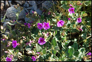
Purple Mat
10-11-2009 @ 9:15 |
Globemallow
10-11-2009 @ 9:41 |
 |
 |
 |
Trailing Four O'Clock
10-11-2009 @ 11:16 |
Western Goldenrod
10-11-2009 @ 2:53 |
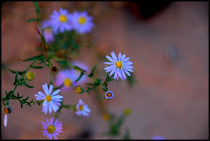
Fleabane Daisy
10-11-2009 @ 3:40 |
Pretty soon the trail becomes much steeper and the exposure increases
greatly. It is clear that there have been several recent scree slides.
We apparently are some of the first to cross them as we see very few
footprints on the "trail." Not only are the new scree slides unstable, but
going across them is like walking on lots of little ball bearings. We
are constantly afraid that our feet will slide out from under us at any
time. A slip here would undoubtedly be fatal. This would not be the place to be without hiking
poles for additional support and stability. My apprehension was
high, hence the absence of more pictures in this area.
 |
 |
Descent below Tilted Mesa
10-11-2009 @ 9:45 |
Descent below Tilted Mesa
10-11-2009 @ 9:45 |
We find lots of the usual desert type plants today.
 |
 |
 |
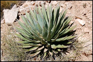
Agave
10-11-2009 @ 9:48 |
Barrel Cactus
10-11-2009 @ 10:16 |
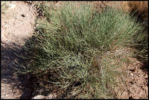
Mormon Tea
10-11-2009 @ 3:16 |
 |
 |
 |
Brittle Bush
10-11-2009 @ 3:16 |
Beaver Tail Cactus
10-11-2009 @ 3:17 |
Prickly Pear Cactus
10-11-2009 @ 3:18 |
We finally get past all the scree slides and are relieved to be below that
very tough section. That was no fun at all. The trail continues its
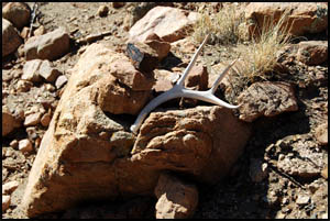
steep descent, but the exposure is gone. Someone has added some
antlers to one of the cairns. Near the bottom, the trail levels out
and the walking becomes considerably easier. Nankoweap Creek is a welcome sight where
we expect the hiking to be much more pleasant than it's been the last
three hours.
 |
 |
 |
Antlers on a rock
10-11-2009 @ 10:45 |
Below the tough stuff
10-11-2009 @ 10:55 |
Nankoweap Creek
10-11-2009 @ 11:13 |
Keith and I reach Nankoweap Creek before noon and briefly look for the
campsite, but don't find it right away. There is evidence of a recent
flash flood here. After lunch, we cache some of our food in a spare Foodsack
for our return in two days. Walking down the creek bed sure beats the
hiking earlier today. We soon discover that most of the sandbars
beside the creek bed have trails that are a lot easier and faster than
cobble stone and boulder hopping in the creek bed. We eventually crest
a small ridge and get our first view of the Colorado River. Camp can't
be too far now.
 |
 |
Nankoweap Creek
10-11-2009 @ 3:17 |
Colorado River
10-19-2009 @ 3:30 |
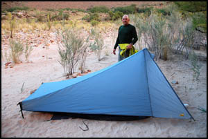
We make camp a few hundred yards upstream from the rafter's beach and
seem to be the only ones here. That's a refreshing change at a popular
place like this.
 |
 |
Keith's tent at the River
10-11-2009 @ 4:07 |
Richard's tent at the River
10-11-2009 @ 4:07 |
Tomorrow we plan to hike up to the Nankoweap granaries and explore a little
on the low ridge above our campsite. It will be nice to have a layover
day here.
MAIN INDEX
|
HIKING INDEX
|
BACK TO
DAY 2
|
FORWARD TO DAY
4
|
Copyright © Richard M. Perry, 2004-2026. All rights reserved. This web site, its text, and pictures may
not be copied without the express written consent of Richard M. Perry. |
|